We build digital products from open data and actionable insight.
Online tools
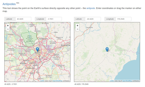
Antipodes Map

What's new on DGU?
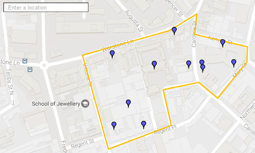
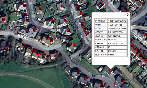
Postcodes in Polygon

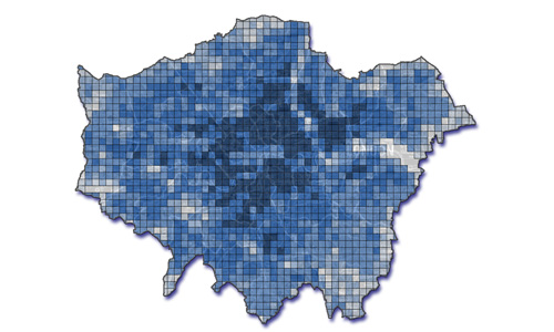
Explore: Age Profiles of Housing Stock in England and Wales
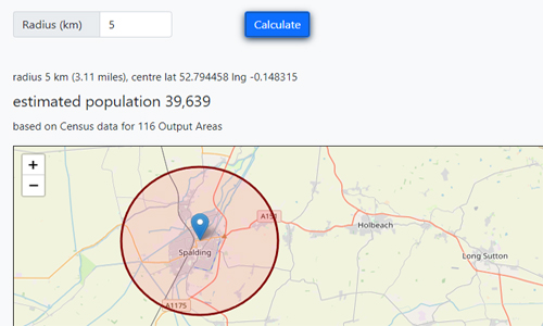
Population within a radius
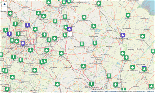
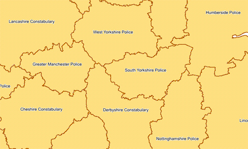
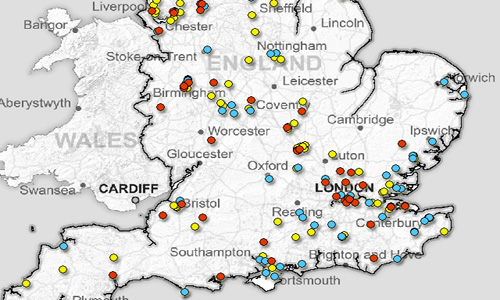
Map: UK Local Government Open Data Sites

Marine Noise Registry (MNR) Browser
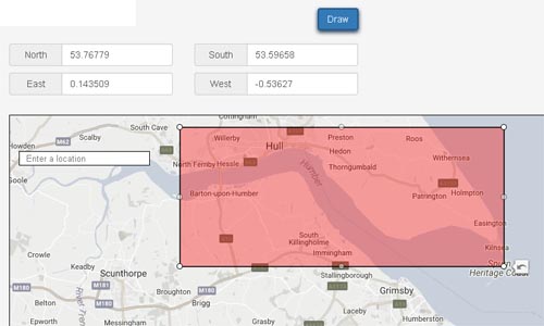
Bounding Box
Free data products
UK Council Tax Address Lists

Large Raised Reservoirs
Large Raised Reservoirs in England and Wales
Large Raised Reservoirs in England and Wales is a spatial data product that contains point locations and other details from public registers of reservoirs maintained by the Environment Agency and Natural Resources Wales. The data is re-usable under the terms of the Open Government Licence.
The 1.9 MB download below contains the data in Shapefile, KMZ and CSV formats.

Climate Observations for Small Areas in England and Wales
Climate Observations for Small Areas in England and Wales
Climate Observations for Small Areas is a collection of climate variables for Lower Layer Super Output Areas (LSOAs) in England and Wales, calculated by sampling the Met Office's annual HadUK-Grid data. The dataset contains averages for rainfall, sunshine duration, and air temperature over the ten years from 2011 to 2020.
The data is re-usable under the terms of the Open Government Licence (OGL). The 3.8 MB download below contains the data in CSV format.
UK Marine Noise Registry (MNR) Snapshot: Archive
The MNR Snapshot is a data product compiled by Datadaptive from records extracted from the UK Marine Noise Registry on 05/07/2018. This is an archived version – more recent snapshots are available.
This data is available for re-use as open data under the terms of the Open Government Licence (OGL). The 3.8 MB download below contains the data in Excel and Shapefile formats.
Datadaptive has also produced an interactive tool that visualises annual mapping outputs from the MNR.
UK Marine Noise Registry (MNR) Snapshot: Archive
The MNR Snapshot is a data product compiled by Datadaptive from records extracted from the UK Marine Noise Registry on 26/06/2019. This is an archived version – more recent snapshots are available.
This data is available for re-use as open data under the terms of the Open Government Licence (OGL). The 3.8 MB download below contains the data in Excel and Shapefile formats.
Datadaptive has also produced an interactive tool that visualises annual mapping outputs from the MNR.
UK Marine Noise Registry (MNR) Snapshot: Archive
The MNR Snapshot is a data product compiled by Datadaptive from records extracted from the UK Marine Noise Registry on 31/07/2020. This is an archived version – a more recent snapshot is available.
This data is available for re-use as open data under the terms of the Open Government Licence (OGL). The 4.9 MB download below contains the data in Excel and Shapefile formats.
Datadaptive has also produced an interactive tool that visualises annual mapping outputs from the MNR.
UK Marine Noise Registry (MNR) Snapshot: Archive
The MNR Snapshot is a data product compiled by Datadaptive from records extracted from the UK Marine Noise Registry on 14/01/2021. This is an archived version – a more recent snapshot is available.
This data is available for re-use as open data under the terms of the Open Government Licence (OGL). The 12.0 MB download below contains the data in Excel and Shapefile formats.
Datadaptive has also produced an interactive tool that visualises annual mapping outputs from the MNR.
UK Marine Noise Registry (MNR) Snapshot
UK Marine Noise Registry (MNR) Snapshot
The MNR Snapshot is a data product compiled by Datadaptive from records extracted from the UK Marine Noise Registry on 05/07/2022.
This data is available for re-use as open data under the terms of the Open Government Licence (OGL). The 8.2 MB download below contains the data in Excel and Shapefile formats.
Earlier snapshots from 2018, 2019, 2020, and 2021 are also available.
Datadaptive has also produced an interactive tool that visualises annual mapping outputs from the MNR.

Collated Public Spend
Collated Public Spend
These datasets are collated from monthly transactions data published by various UK public bodies.
The data is re-usable under the terms of the Open Government Licence.
These datasets are collated from monthly transactions data published by various UK public bodies.
The data is re-usable under the terms of the Open Government Licence.
Cabinet Office spend data April 2010 - June 2026 (3.7 MB XLSX)
Department for Culture, Media & Sport (DCMS) spend data April 2010 - May 2026 (1.5 MB XLSX)
Department for Education (DfE) spend data April 2010 - April 2026 (55.8 MB zipped CSV)
Department for Energy Security and Net Zero (DESNZ) spend data August 2023 - September 2025 (0.9 MB XLSX)
Department for Exiting the European Union (DExEU) spend data July 2016 - January 2020 (17 KB XLSX)
Department of Health & Social Care (DHSC) spend data April 2010 - February 2026 (18.5 MB XLSX)
Department for Science, Innovation and Technology (DSIT) spend data August 2023 - September 2025 (0.3 MB XLSX)
Foreign & Commonwealth Office spend data April 2010 - May 2022 (4.9 MB XLSX)
HM Treasury spend data April 2010 - March 2026 (0.7 MB XLSX)
Ministry of Housing, Communities and Local Government (MHCLG) spend data April 2010 - April 2026 (50.3 MB zipped XLSX)
Population Grid GB 1x1 Km
Population Grid GB 1x1 Km
Population Grid GB 1x1 Km is a high-resolution gridded population dataset covering the whole of Great Britain. The dataset contains Census 2011 resident population data recalculated as estimated headcounts within 1 km x 1 km grid cells.
Datadaptive has released this dataset as open data under the terms of the Creative Commons Attribution License 4.0 (CC BY). The 17.3 MB download below contains the data in both CSV and Shapefile formats.

Historic Landfill in England (Redacted)
Historic Landfill in England (Redacted)
Historic Landfill in England (Redacted) is a subset of the Environment Agency's Historic Landfill dataset, a spatial dataset that defines the location of, and provides specific attributes for, known historic (closed) landfill sites in England. This data product contains the same site records as the source data but with some of the attributes redacted to remove personal data.
The data is re-usable under the terms of the Open Government Licence. The 13.2 MB download below contains the data in CSV and Shapefile format.

Broad Rental Market Area Boundaries
BRMA Boundaries
Broad Rental Market Areas are boundaries that determine Local Housing Allowances rates used to calculate housing benefit for tenants renting from private landlords. BRMA Boundaries is a combined set of BRMA boundaries for England, Scotland and Wales.
Datadaptive has released this dataset as open data under the terms of the Open Government Licence (OGL). The 14.8 MB download below contains the data in Shapefile format.
Also available: a lookup file of 2011 and 2021 Census Output Areas to BRMAs (7.2 MB XLSX), produced using the same boundaries.

Age Profiles of Housing Stock in England and Wales
Age Profiles of Housing Stock in England and Wales
Age Profiles of Housing Stock is an analytic data product derived from statistics published by the Valuation Office Agency (VOA). The product is designed to support comparison and mapping of build periods within small geographic areas. The profiles include metrics for each Lower Super Output Area (LSOA) in England and Wales:
The data product also includes the baseline figures for England, Wales, and each local authority district.
Datadaptive has released this dataset as open data under the terms of the open Creative Commons Attribution License 4.0 (CC BY). The 2.4 MB download below contains the data in CSV format. You can also explore this dataset in our online lookup tool.
Age Profiles of Housing Stock is an analytic data product derived from statistics published by the Valuation Office Agency (VOA). The product is designed to support comparison and mapping of build periods within small geographic areas. The profiles include metrics for each Lower Super Output Area (LSOA) in England and Wales:
- property counts and percentages for 16 build periods from Pre-1900 through to 2024
- median and preferred modal build periods
- a Gini Index calculation of inequality in the age distribution
- a measure of whether the age profile skews 'newer' or 'older' relative to national and local authority baselines
The data product also includes the baseline figures for England, Wales, and each local authority district.
Datadaptive has released this dataset as open data under the terms of the open Creative Commons Attribution License 4.0 (CC BY). The 2.4 MB download below contains the data in CSV format. You can also explore this dataset in our online lookup tool.
UK Police Boundaries
UK Police Boundaries
UK Police Boundaries is a pack of four spatial datasets containing operational boundaries of UK police forces:
The data is suitable for a wide range of applications including thematic mapping and analysis of crime statistics. The data in this pack is re-usable under the terms of the Open Government Licence.
The 94.8 MB download below contains the data in Shapefile format along with documentation.
UK Police Boundaries is a pack of four spatial datasets containing operational boundaries of UK police forces:
- UK Police Force Areas
- Local Resilience Forums (England and Wales)
- Scotland Police Divisions
- Northern Ireland Policing Districts
The data is suitable for a wide range of applications including thematic mapping and analysis of crime statistics. The data in this pack is re-usable under the terms of the Open Government Licence.
The 94.8 MB download below contains the data in Shapefile format along with documentation.

UK Wind Energy Locations
UK Wind Energy Locations
UK Wind Energy Locations is a dataset of point locations for onshore and offshore wind energy projects with a capacity greater than or equal to 1MW.
Datadaptive has produced this dataset by geocoding an extract from the UK Government's Renewable Energy Planning Database (REPD). REPD extracts are published quarterly. The data is re-usable under the terms of the Open Government Licence.
The 2.0 MB download below is the July 2024 release and contains the data in KMZ (for Google Earth), Shapefile, and Excel formats. For the time being, Datadaptive is no longer updating this dataset.
Public Land for Housing
Public Land for Housing
Public Land for Housing is a free data product that contains some basic information about sites in England, previously owned by Government departments, that have been declared surplus and sold for housing development.
Datadaptive has extracted the site records from a report published by the Department for Levelling Up, Housing and Communities (DLUHC), and geocoded the postcode location of each site. The data is re-usable under the terms of the Open Government Licence.
The 17.0 MB download below is the September 2022 release and contains the data in Shapefile and Excel formats. The zip file also contains archived copies of the February 2017, March 2019, and February 2020 releases.

Major Towns and Cities - Population
Major Towns and Cities - Population
Major Towns and Cities - Population is a data pack that contains three types of Census 2011 population total and a mid-2017 population total for the built-up areas of 112 large settlements in England and Wales.
Datadaptive has compiled this data pack as a source of denominators for statistical work based on ONS's experimental Major Towns and Cities geography.
The data is re-usable under the terms of the Open Government Licence. The 6.2 MB download below contains the data in CSV and Shapefile formats.

Jobcentre Locations GB
Jobcentre Locations GB
Jobcentre Locations GB is a spatial data product that contains point locations for Department of Work and Pensions (DWP) jobcentres in England, Scotland and Wales.
The data is re-usable under the terms of the Open Government Licence. The 0.6 MB download below contains the data in CSV and GeoJSON formats.
UK and Ireland Coastlines
UK and Ireland Coastlines
UK and Ireland Coastlines is a spatial dataset containing coastal and inland boundaries for England, Scotland, Wales, Northern Ireland, Ireland, the Isle of Man, and the Channel Islands.
The combined dataset is re-usable under the terms of the open Creative Commons Attribution License 4.0 (CC BY). The 32.9 MB download below contains the data in Shapefile format.
Water Lines GB
Water Lines GB
Water Lines GB is a product that contains vector data for mean high and mean low water lines around the coast of Great Britain. The vector data has been collated from the contour version of the July 2018 release of Ordnance Survey's OS Terrain 50. The data is re-usable under the terms of the Open Government Licence.
The 29.7 MB download below contains the data in Shapefile format.

UK Reservoir Locations
UK Reservoir Locations
UK Reservoir Locations is a spatial data product that contains point locations and other details from an inventory of reservoirs published by NERC. The data is re-usable under the terms of the Open Government Licence.
The 0.6 MB download below contains the data in Shapefile, KMZ and CSV formats.
UK Reservoir Locations is a spatial data product that contains point locations and other details from an inventory of reservoirs published by NERC. The data is re-usable under the terms of the Open Government Licence.
The 0.6 MB download below contains the data in Shapefile, KMZ and CSV formats.

UK Post Office Locations
UK Post Office Branch Locations
UK Post Office Branch Locations is a dataset that contains point locations for Post Office branches in England, Scotland, Wales and Northern Ireland, with the exception of some non-public sites.
Datadaptive has recompiled this dataset from source data released by Post Office Ltd in October 2023. The data is re-usable under the terms of the Open Government Licence.
The 3.6 MB download below contains the data in Shapefile and CSV formats.

Experimental Urban Extents for Natural Capital GB
Experimental Urban Extents for Natural Capital (GB)
Experimental Urban Extents for Natural Capital (GB) is a dataset containing metrics that quantify the extent of different classes of blue and green space within the urban environment of Great Britain.
Datadaptive has compiled this dataset from source data released by the Office for National Statistics (ONS) in 2019 as part of experimental work on natural capital accounting. The data is re-usable under the terms of the Open Government Licence.
The 66.5 MB download below contains the data in Shapefile and CSV formats.
More information
Datadaptive is a side project of Owen Boswarva that focuses on release of free open data products and tools.
Datadaptive is not currently marketing data products on commercial terms. However, Datadaptive's Postcode to BRMA Lookup is available on request.